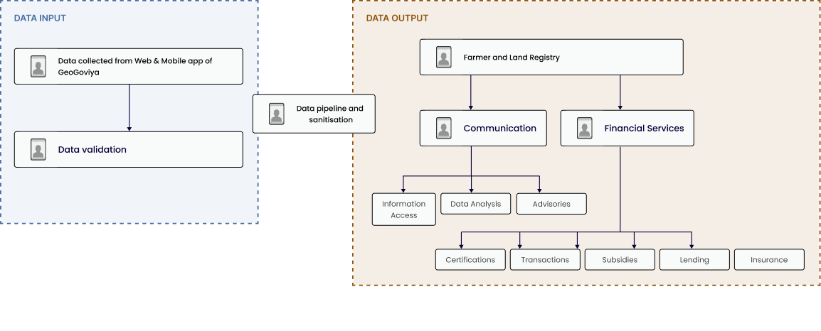
Features

Exploring GeoGoviya's Core Features

Explore our unique set of features below

Dashboard
Dashboard User Data

This dynamic dashboard is your portal to managing an extensive farmers database, viewing detailed farmer requests, and accessing critical data for paddy and high lands. Stay informed with the latest cultivation, forecast, and harvest updates.

CultivateX (Crop Advisory)
Growth for Every Farmer

data-driven advisory services to help you make informed decisions throughout the farming cycle. From weather forecasts to crop-specific guidance and market insights, your go-to resource for enhancing productivity and sustainability.

Digitalised Land Parcel
Your Farm Dashboard Statistics

Gain insights into your farm operations with real-time statistics. Track user and farmer growth with detailed analytics to guide your agricultural decisions.

Cash Grants
Track Farm Activities

Monitor your farm's recent activities with ease. From user data approval to paddy land updates, GeoGoviya keeps you informed about every action taken, ensuring transparency and control.

Data Uploads
Overview Dashboard & User Details

GeoGoviya provides a comprehensive overview of your farm's data, from crop advisory to land details. Utilize our user-friendly dashboard to make informed decisions for your farming business.

Form land management
Field Monitoring

Users can remotely monitor their fields and operations through the dashboard, allowing them to keep track of activities even when they are not physically present on the farm.

Crop health monitoring
powered by EO4ARM
Monitor past and current conditions

The tool allows the users to monitor past and current conditions of crop and available water resources which helps to determine the drought/flood conditions to promote proactive disaster management measures for the insurance.

GeoGoviya Android App

GeoGoviya is an intuitive Android-based platform that streamlines two-way agricultural data for smallholder farmers, enhancing productivity and income. It offers a cost-effective solution for crop monitoring and user interaction via geotagged insights at the farm level.

How It Works

Data input

Data from source field enumerator or data collected from Mobile App

Uses an Android based mobile app to collect/submit information about the farmer and the homestead

gps co-ordinates of the farm
Farmer info with picture
Data from Web app

A web-interface to collect reporting data on various indicators (component and contextual)

Data Processing

server
Configuration modules

Web-based, menu-driven UI Interface to configure country/project level temptes, tools, units, conversions etc.,

cloud based analytics engine

Data Output

multi-layered dashboard for detailed insights
Province/ District/ DS/ ARPA/ ASC : M&E OFFICERS

Track progress, take corrective measures, Generate informed evidence-based data

api

To share/feed data into other data platforms

GeoGoviya Data Architecture Framework

Farmer Profiles Management

Personal

Farmer’s identity and household
details

Communication

Phone number(s), phone type,
phone literacy, email, social
networks

Location

Administrative address and GPS
coordinates

Financial
Instruments

Credit, insurance or subsidies
payments, bank and mobile
money accounts

Credit

Credit record, farm business plan,
active credit information

Insurance

Includes field(s), covered, risk(s)
covered, cost, company, amount
repaid in case of the risk(s)
materialize

Farm

Location, size, elevation, soil, land
title and crop history

Planting

Date, spacing, intercropping,
equipment, seeds used

Activities

Treatment applied, fertilzer,
extension service interventions,
pest & disease attacks &
treatments, activities such as
weeding, water usage, yield, loss,
rainfall

Agri Businesses

Co-operatives/production cluster
membership, markets the farmers
is linked to, agri-businesses
linkages, total amount of products
sold and prices sold

Technology Stack and Architecture

front end:

Angular 14 with responsive and dynamic UI.
Angular Material or similar UI libraries for consistent styling.

back end:

Python (Flask or Django) for REST API development.
User authentication and authorization mechanisms.

Satellite Imagery and Yield Forecasting:

Integration with satellite imagery analysis tools (e.g., Google Earth Engine).
Scripts for satellite data processing and yield forecasts.

Database:

MYSQL for structured data storage.
Normalized tables with foreign keys and indexes.

QR Code Generation:

QR code generation libraries for Python.

Mapping and Visualization:

Mapping libraries like Leaflet or Mapbox for KML visualization.

Deployment and Hosting:

Docker for deployment to ensure scalability and maintainability.